Kalypso
Nosso projeto de referência
nofdp IDSS
| Services: | Design and implementation of the software, GIS, ecology, 1-dimensional hydraulic model |
| Duration: | 2006-2007 |
| Technology: | Eclipse 3.3; implementation and deployment of OGC (Open Geospatial Consortium) standards: GML 3.1, Observation & Measurement, Web Map Service, Web Feature Service; Apache Tomcat, XML (JAXB, DocBook, xsltproc), OpenOffice, Google Earth |
nofdp (nature-oriented flood damage prevention) has been designed by the Hessian Ministry for Environment, Rural Areas and Consumer Protection in the context of the EU INTERREG III B program in order to provide means for environmentally oriented flood protection measures. Project partners are the Technical University of Darmstadt, the Federal Institute of Hydrology, the Province of Noord-Brabant and the water associations Brabantse Delta, Aa en Maas, Dommel and Mümmling.
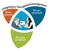
The nofdp IDSS (nature-oriented flood damage prevention Information and Decision Support System) has been designed as a special tool for planners and decision-makers in water associations. Thus, they are provided with an instrument for the preliminary planning phase which allows them to have an integrative view on river catchment areas in order to improve flood damage protection taking aspects of spatial planning, water resources management and ecology into account.
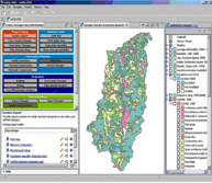
nofdp IDSS provides planners and decision-makers with a series of mostly GIS-based tools.
Tools
- Analyzing the project area (e.g. conflict detection, assessment of potential vegetation units, identification of potential areas for water retention, suggestions for effective restoration measures based on eco-morphological river quality data),
- Creating hydraulic models (SOBEK),
- Carrying out flood risk analysis,
- Planning measures and defining variants,
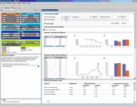
- Evaluating these variants in terms of their impact on conflict areas and ecology (e.g. ranking, rating, Value Benefit Analysis, Cost-Effectiveness Analysis),
- Supporting the communication process with other project partners and the public (e.g. report generation, Google Earth interface) and
- Importing and exporting project data for an exchange with external systems.


