Kalypso
Nosso projeto de referência
Sistema de Suporte à Decisão (SSD) Informe
| Services: | Design and implementation of the system, software development, GIS, ecology |
| Duration: | 2005-2008 |
| Technology: | Eclipse 3.3; implementation and deployment of OGC (Open Geospatial Consortium) standards: GML, Observation & Measurement, Web Map Service, Web Feature Service, Web Processing Service; Web Authentication Service, Web Security Service, Apache Tomcat, XML (JAXB, DocBook, xsltproc), OpenOffice |
The Federal Institute of Hydrology (BfG) develops in the context of applied research the modeling system INFORM (Integrated FlOodplain Response Model). This system provides an integrated view on processes in the floodplain. The objective is to elicit environmental effects of changes in the floodplain and evaluate these changes.
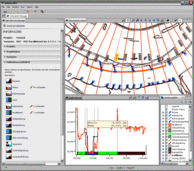
On the basis of this modeling system, the decision support system INFORM.DSS (DSS decision support system) is being developed which will serve in the Water and Shipping Administration as a planning tool. Users of INFORM.DSS define river construction measures (e.g. groins, river bed excavations, terrain adjustments to the foreshore, dyke relocations, land use changes) and interactively model the impacts of these measures on the water table as well as ecological parameters.
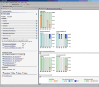
The hydraulic calculations are performed on the INFORM.DSS-Server which is located at BfG. The ecological modeling is performed by an expert team of the BfG. INFORM.DSS integrates all of these processes including data management and presents the modeling results in its geographical context.
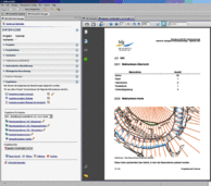
Based on OpenOffice, INFORM.DSS generates complex structured project reports. While working with INFORM.DSS geodata may be accessed which are stored in the spatial data infrastructure system GGina of the Federal Institute of Hydrology.
The Federal Institute of Hydrology (BfG) develops in the context of applied research the modeling system INFORM (Integrated FlOodplain Response Model Decision Support System). This system provides an integrated view on processes in the floodplain. The objective is to elicit environmental effects of changes in the floodplain and evaluate these changes. On the basis of this modeling system, the decision-support system INFORM.DSS (DSS decision support system) is being developed which will serve in the Water and Shipping Administration as a planning tool. Users of INFORM.DSS define river construction measures (e.g. groins, river bed excavations, terrain adjustments to the foreshore, dyke relocations, land use changes) and interactively model the impacts of these measures on the water table as well as ecological parameters. The hydraulic calculations are performed on the INFORM.DSS-Server which is located at BfG. The ecological modeling is performed by an expert team of the BfG. INFORM.DSS integrates all of these processes including data management and presents the modeling results in its geographical context.
Based on OpenOffice INFORM DSS generates complex structured project reports. While working with INFORM DSS geodata may be accessed which are stored in the spatial data infrastructure system GGina of the Federal Institute of Hydrology.


