Kalypso
List of Products
Kalypso Risk
complements the post-processing palette of Kalypso with a module for determining flood risks along the course of rivers.
On the basis of land use data and flow depths the module provides means for determining damage potentials for predefined flood events and yearly expected damage values as well as allocating risk zones. In particular for determining annually expected damage values, flow depth data from a variety of flood events corresponding to different return intervals are required.
Land use data are imported as Shape data into Kalypso Risk. Flow depths are imported as raster data in ESRI ASCII Grid format; the user interface of Kalypso Risk provides efficient management tools for carrying out these tasks.
Annual expected damage values are computed based upon a mesoscale approach for monetary values (specific asset allocations to land use categories) and user selected stage-damage functions which determine the relationship between water depth and structure damage (see "Technical Bulletin of BWK 1/2001: Flood Damage Potentials", only available in German).
The user of Kalypso Risk can choose between working with specific asset values and stage-damage functions defined by himself or applying existing material from e.g. the International Commission for the Protection of the Rhine (IKSR) or the International Commission for the Protection of the Elbe River (IKSE).
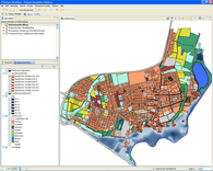
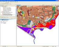
Flood risk categories are derived from the annually expected damage values. By defining limiting values on this scale the user can identify six risk categories which are depicted on a map of the study area.
Flood risk categories
- Settlement areas, highly affected
- Settlement areas, medium affected
- Settlement areas, little affected
- Unsettled areas, highly affected
- Unsettled areas, medium affected
- Unsettled areas, little affected

