Kalypso
List of Products
Kalypso Flood
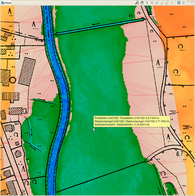
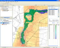
is a post-processing module for determining and displaying inundated areas and flow depths on the basis of digital terrain model data and water surface profiles. Kalypso Flood works with ESRI ASCII grid formatted data with arbitrary spatial resolution.
During data processing every cell of the digital terrain model data is assigned a water surface profile value from the water surface profile data and by determining the difference of these values flow depths for every grid cell are calculated. This results in a flow depth grid inheriting the cell size and spatial resolution from the digital terrain model being applied. Water profile data are directly imported from Kalypso WSPM and Kalypso 1D/2D. Water profile data from other sources may be imported with BCE HMO and ESRI ASCII Grid formats.
Kalypso Flood allows for merging different model and intersection results into a single result set thus providing means for combining separately computed model segments for further processing. This result set also serves as input for Kalypso Risk for determining damage potentials and risk maps.
Further, Kalypso Flood provides means for data editing to the user. For example, clip and extrapolation areas may be defined in order to exclude areas from intersection processes or to assign water level data to areas with no water level data for determining overall inundated areas.
The result sets may be exported in ESRI ASCII Grid format for further processing with other software.

