Kalypso
List of Products
Kalypso WSPM
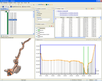
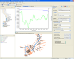
is a module for computing one-dimensional water surface profiles. The standard version contains the computation module from the Institute of Hydraulic Engineering at the Technical University of Hamburg-Harburg - also referred to as PASCHE computation module. This module supports the newest methods and approaches which have been standardized in Germany for carrying out hydraulic computations for near-natural creaks and rivers and are summarized in the Technical Bulletins 1/1999 of BWK and 220/1991 of DVWK.
Main features of the computation module are
- Stationary non-uniform computation of water surface profiles and
- optionally taking the flow laws of DARCY-WEISBACH or GAUCKLER-MANNING-STRICKLER into account,
- Consideration of separation plane roughness according to PASCHE,
- Consideration of fouling roughness according to LINDER and PASCHE,
- Computation of bridges with complex geometries while taking different flow conditions into account,
- Computation of weirs with one or more fields and
- Determination of Kalinin-Miljukov parameters for flood routing in precipitation-runoff simulations (see Kalypso Hydrology).
Main features of the graphical user interface include inter alia:
- GIS-based input and presentation of hydraulic data,
- Import of existing WSPWIN projects including cross section data in Triple Format,
- Assignment of cross section attributes according to imported roughness and fouling zones,
- Cross section validation including means for automatic adjustment,
- Automatic historization of model results for carrying out scenario comparisons,
- Interface with Kalypso Flood for determining inundated areas,
- Integration of publicly available Web Map Services (WMS),
- Interfaces to commonly used vector and raster data formats (Shape format, ESRI ASCII Grid).