|
|
| Line 4: |
Line 4: |
| | | | |
| | There are a bunch of issue fixes. | | There are a bunch of issue fixes. |
| − | # Fixes that belonged to never published version 15.1.2: <TODO: Report has to be created>; [https://dev.bjoernsen.de/kalypso/query?resolution=fixed&milestone=15.1.2&group=component&col=id&col=summary&col=milestone&col=type&col=status&col=priority&col=component&order=priority intermediate link to list of fixes to 15.1.2 within Trac (no report!)] | + | # Fixes that were done for version 18.2 and -never published - version 15.1.2: [http://dev.bjoernsen.de/kalypso/report/45 Kalypso Trac report 45] |
| − | # Fixes that were done for version 18.2: <TODO: Report has to be created>; [https://dev.bjoernsen.de/kalypso/query?resolution=fixed&milestone=18.02&group=component&col=id&col=summary&col=milestone&col=type&col=status&col=priority&col=component&order=priority Intermediate Link to list of fixes to 18.2 within Trac (no report!)]
| + | |
| | | | |
| | ==Kalypso Platform== | | ==Kalypso Platform== |
Latest revision as of 10:24, 5 March 2018
Changes since: Kalypso-15.1 (Change_Log_Kalypso_15.01)
[edit] Kalypso issue fixes
There are a bunch of issue fixes.
- Fixes that were done for version 18.2 and -never published - version 15.1.2: Kalypso Trac report 45
[edit] Kalypso Platform
Items that improve Kalypso in general.
| Kalypso is newly based on up-to-date Eclipse Oxygen.2 (version 4.7.2, Nov. 2017)
(https://www.eclipse.org/eclipse/news/4.7.2/)
|
|
| There were tremendous changes to KalypsoBASE plattform to generate more reliable and strengthened modularity of Kalypso implementaiton means. Many specific tools were refactored and - where possible - generalized.
|
|
Map view and its outline newly support drag and drop. You can
- drag an external file (ESRI shape and Images supported for now) into the map
- drag layers within the outline view
|
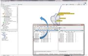 Drag & drop files from any file browser |
[edit] Consumability / Reliability
Items that make it easier for users to get Kalypso, install it on their systems, and configure it for their use.
| Definition of folder to put calculation engines (like rma-kalypso_<version>.exe or kalypso-na_<version> can be defined by user environment settings. This allows to not copy engines from installation to installation, but to just install Kalypso without any further adaptations of engine locations. The environment variable is named "KALYPSO_CALC_CORES_DIR" and should contain all executable files to be used (accept Telemac engine which is adressed by its environment variables)
|
 Example definition of environment variable to locate calculation engines |
[edit] KalypsoHydrology
| Hydrology newly supports import of meshing within importable shape-files. User can handle relations by name and store them previously in shape files. This might result from data sets which already contain the meshing information.
|
|
[edit] Kalypso1D2D
Full support of Telemac2D. This includes:
- Meshing, setting up boundary conditions, simulation setup
- In-bound simulation triggering
- Support of parallel simulation triggering
- Export of prepared jobs to dedicated locations to modify steering file and add options/settings, that are not supported by Kalypso
- Import simulated jobs
- Integration of results evaluation procedure of Kalypso, i.e. full support of features allowed for RMA and Hydro_AS-2D
- Restarting from Telemac results or any other results
|
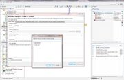 Telemac simulation settings 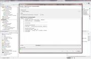 Simulation panel during Telemac computation |
Add support of Acute triangulation tool to generate orthogonal meshing. aCute is an extension to Shewchuk's "Triangle" (https://www.cs.cmu.edu/~quake/triangle.html) from Erten and Üngör (https://www.cise.ufl.edu/~ungor/aCute/references.html). Take care to comply with 3rd parties' rights.
- Delauney conforming meshing
- maximum angle constraint
- fewer triangles using same settings as for Triangle
|
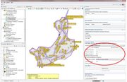 Integration of aCute to triangulation tool 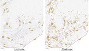 Concurrent use of Triangle and aCute using equal settings for triangulation and quality checks |
Integration of conceptual model features for the purpose of triangulation
- Consideration of boundary polygons, breaklines, forced nodes, holes (such as buildings)
- Refinement polygons
- Import of features from e.g. shape-files via context menu in map outline
- adding, deleting, re-shaping of conceptual model features
- separate consideration / exclusion of features during meshing
|
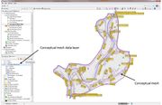 Conceptual mesh data with editing toolbar, outline and representation in map |
Improved triangulation tooling
- Added option to select meshing algorithm from Triangle / aCute
- sweepline
- divide and conquer
- Incremental
- Added snapping tolerance to adjust inaccuracies in base (conceptual) mesh data
- Added different meshing options to attach projected triangulation to existing mesh. Allowed are:
- Ignore mesh: New meshing will be done without considering existing elements. When finalizing the mesh all elements that intersect existing mesh parts will be refused.
- Add mesh boundary as breakline: Meshing will be carried out as in "Ignore mesh", but boundaries of exisiting meshs will be extracted and considered with all nodes.
- Patch to existing mesh: All overlaps of existing mesh and triangulation polygon will be erased to obtain a new meshing boundary.
- Patch to existing mesh with extra boundary: Same as "Patch to existing mesh" but puts a buffer around.
Those tools are still in testing phase. The key issue is that on the neatline to an existing mesh no additional nodes (Steiner nodes) are desired on arcs, whereas on outer boundaries they are desired. Please make your own experiences. We are going to eliminate the options in further versions after finding the best procedure in our opinion. Any hint on user or developer mailing list is welcome.
|
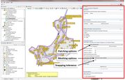 Extended Triangulation Options |
Improved computational mesh validation:
- Allow for enabling / disabling specific mesh validation rules
- Added further net validation options
|
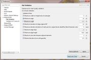 Individual configuration of consedered mesh quality options. |
Added functionality for river channel editor
- Newly, elements can be generate based on given river axis and flow dividers (flow bounds, imaginary walls, bankful points) defined in profiles. Meshing-Profiles will not be adjusted by up- and downstream profiles of section to be meshed, but based on perpendicularity to given river axis.
- Alow to specify element lengths absolute or based on widht-length ratio
- River axis can be taken from belonging cross section data set or from any imported shape file
|
|
Improved cross section management
- cross section management in 1d2d now supports almost all features available in WSPM (including direct access to cross section database)
- cross section management is now structured similar to WSPM model (i.e. water bodies and reaches are now modelled as well) including management of a river axis
- Adapt visualization scaling of profiles in cross section view; width:
- show available width
- divided
- bankful point
- flow area
- center on lowest point (including width specification)
- height:
- show available height
- adjust to lowest point (including height specification)
When scrolling through profiles these settings remain which eases the visual comparability of profiles from one to the other.
|
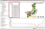 Improved cross section management (Integrated WSPM data model to 1D2D)  Example application of centering to deepest point |
Added cross section menagement tools:
- Added cross section management tool to straighten and orthogonalize profiles based on given river axis geometry. This helps generating smooth river channel meshes.
- Adjust width coordinates to deepest points of profiles, so that deepest point will get width = 0.0m, left negative, right positive.
|
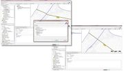 Example application: Straightening of profiles |
Basic DFlow-FM (Deltares) support:
- Reading / Writing DFlow FM netCDF files including mesh with / without results
- Export cross section profiles including buildings in DFlow-FM format (prepare buildings)
- Export roughness polygons in xyz format
- elevation models may be exported in the xyz format
|
|
| Export of profiles (tripple, csv, wspr) now transform the coordinates of profiles into a given target coordinate system. It can be used for WSPM and cross section management in 1D2D
|
|
| Allow to export digital height models as .xyz point files. This functionality arises from DFlow-FM basic support, but yields benefits for all modules.
|
|
[edit] KalypsoWSPM
| Empty, please replace me with a real entry.
|
|
[edit] KalypsoRisk
| Empty, please replace me with a real entry.
|
|


