Changes since: Kalypso-11.6
Kalypso Platform
Items that improve Kalypso in general.
| The tool for selecting features in a map now has a 4th selection mode: 'Hover'. In this mode, the selection follows the mouse cursor without need for a click in the map.
|
|
| Support for GML 2 has been dropped, Kalypso now supports only GML 3. The GML parser has been reworked to use less memory and has less performance impact during startup.
|
|
Consumability / Reliability
Items that make it easier for users to get Kalypso, install it on their systems, and configure it for their use.
| Improved installation process. Separate installers for 32bit and 64bit systems are now available. The data workspace is now saved in the user profile by default.
|
|
KalypsoHydrology
| Simplified project structure. Removed some obsolete folders and moved all internal folders into '.model'. All basis data is now in folder 'Basis', similar to the project structure of workflow based projects (i.e. 1D2D, Flood, Risk).
|
|
| The Table views for subs catchments of the basis model are now identical to the table views of the calculation case. I.e. there are multiple views for the catchment table (calibration, general properties etc.).
|
KalypsoWSPM
| The cross section legend view now selects the first entry when first shown. It also remembers which layer was shown when the selected cross sections changes. I.e. if the user browses through the cross sections, the legend keeps the selected element.
|
|
| The current mouse position is now always displayed at the bottom-right of the profile chart.
|
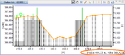 Position in profile chart |
| A new tool allows to interpolate (and extrapolate) missing profile point geometries.
|
|
| TODO: Synchronization of selection between Map, Table and ChartView
|
|
| TODO: Select Profile Point Tool (Map, ChartView)
|
|
| Two new tools allow to insert new points into a cross section via the map and the chart. The new point is inserted at the mouse position and its parameters are interpolated from it's neighboring points.
|
|
| It is now possible to import water bodies from a shape file. The import allows to update existing water bodies as well as to import new ones. The import reads reference number, label, description and rank from the attributes of the shape. In particular, the imports allows to import a center line into the WSPM model. The center line will be basis for a number of future functions of WSPM.
|
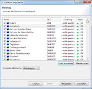 Preview of imported water bodies |
| A new tool allows to derive a river line from its cross sections. At the moment, the method simply concatenates the position of each lowest point of each section.
|
|
| EXPERIMENTAL: A new export method allows to build smooth bank lines from a river line and marker points (e.g. bank full points) of a set of cross sections. This function relies on a new algorithm that builds a geometric buffer with variable distances for each intersection between a cross section and the river line.
|
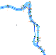 Bank line derived from cross sections and river line |
KalypsoRISK
| A new evaluation methods allows to groups the calculated damages by an arbitrary shape file.
|
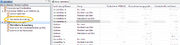 Damages grouped by arbitrary areas |
KalypsoXXX
| Empty, please replace me with a real entry.
|
|


