Difference between revisions of "CreateProject/CreateNewProject/hydrology/en"
BhawaniRegmi (Talk | contribs) (→Create New Project) |
BhawaniRegmi (Talk | contribs) |
| (One intermediate revision by one user not shown) | |
Latest revision as of 14:10, 4 January 2017
[edit] Create New Project
A new project can be created at Start Page via clicking the ![]() Create New Project.
See Create Projects in the General Kalypso manual.
Create New Project.
See Create Projects in the General Kalypso manual.
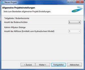
In the case of KalypsoHydrology, additional information about the structure of the project can be obtained when the project is made and the basic model elements from the shape file are imported. After naming the project, the number of modelled soil layers and the number of the identified discharges (number of Kalinin-Miljukov parameter) is set Definition of Preconditions). The maximum number of different soil layers is currently limited to 10 and the number of the Kalinin-Miljukov parameter is set to 5. Afterwards, the wizard performs the import of shape files of sub-catchments, strands, nodes and possibly hydrotope (see Hydrotope). The following tables show an overview of the elements which must be present in the model as shape files.
When entering the content, the procedure is as follows: If you want to import sub-catchments, strands, nodes, and hydrotope, you must first activate the box for e.g. Importing sub-catchments to activate the dialog box for the import. By using the button ![]() the shape file can be selected for the import. In the further process, the four shape files for sub-catchments, strands, nodes and hydrotopes are read one after the other. To do this, select the required file with the file browser and undertake a mapping of the columns of the shape file to the elements of the model. The associated coordinate system must be selected when importing the respective shape files (E.g. for Hamburg: DHDN / 3-degree Gauss-Krüger zone 3). The files of the sub-catchments, strands, nodes and hydrotopes (optional)are processed one after the other. After assignment of the hydrotopes, the wizard is completed by clicking on
the shape file can be selected for the import. In the further process, the four shape files for sub-catchments, strands, nodes and hydrotopes are read one after the other. To do this, select the required file with the file browser and undertake a mapping of the columns of the shape file to the elements of the model. The associated coordinate system must be selected when importing the respective shape files (E.g. for Hamburg: DHDN / 3-degree Gauss-Krüger zone 3). The files of the sub-catchments, strands, nodes and hydrotopes (optional)are processed one after the other. After assignment of the hydrotopes, the wizard is completed by clicking on ![]() button.
button.
[edit] Procedure Overview
To create a new project, it is recommended to start on the Welcome Page of KalypsoHydrology.
- 3. Specify project-specific preconditions
- 3.1 Sub-division of soil horizons (number of soil layers)
- 3.2 Kalinin-Miljukov strands (number of the discharges, which were determined by the hydraulic model)
| The number of hydraulically calculated discharges is fixed to a number of five. Here, no editing is possible. |
- 4. Import the GIS-Data. The assigned elements are:
| Mapping of the properties of the sub-catchment | Meaning |
|---|---|
| Co-ordinatensystem | Specification of the co- ordination system |
| Name | sub-catchment number with 4 digits |
| The assignment of names for the individual elements shall be done with 4 digits. This four-digit number should be greater than 1000 and less than 7999. It should be noted that the term "8000" identifies a node outside of the catchment. Source or initial nodes are named "9000". Currently, the maximum number of sub-catchments on one strands is 6. If this leads to restrictions, you may contact the Institute of River and Coastal Engineering at the Hamburg University of Technology Hamburg-Harburg. |
| Properties of Hydrotopes | Description |
|---|---|
| Co-ordinate system | Specifications of the coordinate system |
| Name | Name of the Hydrotope |
| Land use Key | Abbreviation of land use (Allocation to the globally defined usage parameters ) |
| Soil profile | Abbreviation of soil profile. (Allocation to the globally defined soil parameters) |
| Correction factor of Sealing rate | Correction of the sealing rate of the defined land use (Allocation to the globally defined land use parameter ) |
| Max. Percolation rate [m/s] | Hydraulic conductivity, with which the percolation from the last layer of soil can penetrate into the GW. |
| Ground water inflow | Part of groundwater, which remains in the upper aquifer. The differential portion is cut off in the deep aquifer. |
- 5. The new project will be displayed in the project overview.
There is the possibility of finishing the import-wizard after importing the strands (keyword: hydrotope intersection in KalypsoHydrology).
| There is the possibility of finishing the import-wizard after importing the strands (Key word: Hydrotope intersection). The import of the hydrotope shape file is possible, but it is recommended that the intersection of the Hydrotopes should be done directly in KalypsoHydrology. When the window opens for importing the Hydrotope file, the model can be created already by clicking on |
| Language: | English |
|---|
