Difference between revisions of "Parameterdefinition/Soil/hydrology/en"
From Kalypso
BhawaniRegmi (Talk | contribs) (Created page with "== Soil == Es wird unterschieden zwischen Bodenart (Horizonte) und Bodentypen (Profile, siehe [[Allgemeines/AufbereitungBodendaten/hydrology/de|''Aufbereitung von Bodendaten''...") |
BhawaniRegmi (Talk | contribs) |
||
| Line 1: | Line 1: | ||
| − | == Soil == | + | == Soil Profile == |
| − | + | A distinction is made between the soil type (horizons) and soil types (Profile, See [[Allgemeines/AufbereitungBodendaten/hydrology/de|''Preparation of soil data '']]). | |
| − | === | + | ===Views to the editing of the soil=== |
| − | + | Following three views are available here: | |
| − | ; | + | ; Horizons |
| − | : | + | : The term ''Horizons'' stands for ''Soil horizons''. The (ground) horizon may refer to an area in the floor with almost the same properties, which differs from the above or below following (floor) horizon. The sum of the stacked horizons of a soil make the ''Soil'' profile. |
; Profile | ; Profile | ||
| − | : | + | : The sum of the layered different soil horizons is known as soil profile. |
; Feature View | ; Feature View | ||
| − | : | + | : Editing window for the item properties. |
| − | === | + | === Procedure === |
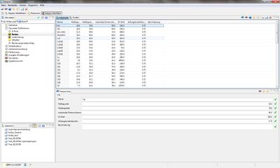
| − | + | In the subsection of the menu select ''Parameter Definition'', and then select the''Soil''( See Figure [[:File:Boden Horizonte.jpg|''View of entering the horizons'']]) | |
| − | ==== | + | ==== Horizons==== |
| − | [[File:Boden Horizonte.jpg|thumb|400px|right| | + | [[File:Boden Horizonte.jpg|thumb|400px|right|View of entering the horizons]] |
| − | + | First, the used soil horizons and their parameters is collected. A database of KalypsoHydrology is available, which must be supplemented if necessary. Add the soil types and proceed as follows: | |
| − | :1. '' | + | :1. Select ''Horizons''- Database |
| − | :2. | + | :2. With the button [[File:Feature hinzufuegen.png|25px]] ''Feature New'' insert a new soil horizon in the tables (See Figure [[:File:Boden Horizonte.jpg|''Display at entering the horizons'']]) |
| − | :3. | + | :3. In the ''Feature View'' enter the Name, Welting point, Field Capacity, Maximum pore volume, Kf-value and Initial soil moisture (See Table ''Soil Horizon Lists'') |
{| class="wikitable" style="width:600" | {| class="wikitable" style="width:600" | ||
| − | |colspan="5" style="text-align:center" | ''' | + | |colspan="5" style="text-align:center" | '''Soil Horizon lists''' |
|- style="text-align:center" | |- style="text-align:center" | ||
|width="20%"| '''Parameter''' | |width="20%"| '''Parameter''' | ||
| − | | width="10%" | ''' | + | | width="10%" | '''Unit''' |
| − | | width="10%" | ''' | + | | width="10%" | '''Value Type''' |
| − | | width="40%" | ''' | + | | width="40%" | '''Significance''' |
| − | | width="20%" | ''' | + | | width="20%" | '''Data type''' |
|- | |- | ||
| − | | | + | | Wilting point||[mm/dm]||[ - ]||Wilting point ||Number (double) |
|- | |- | ||
| − | | | + | |Field Capacity||[mm/dm]||[ - ]||Field Capacity||Number (double) |
|- | |- | ||
| − | | | + | |Maximum Pore volume||[mm/dm]||[ - ]||Maximum Pore volume||Number (double) |
|- | |- | ||
| − | |kf- | + | |kf-Value||[mm/d]||[ - ]||Water Permeability Number ||Number (double) |
|- | |- | ||
| − | | | + | |Initial soil Moisture||[-]||[0-1]||Initial soil moisture content in relation to the maximum soil moisture .||Number(double) |
|} | |} | ||
| − | :4. | + | :4. Using the button [[File:Feature löschen.png|25px]] '' Delete Features'' can delete Soil Horizon-Features. |
==== Profile ==== | ==== Profile ==== | ||
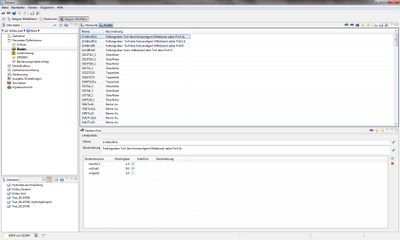
[[File:Boden Profile.jpg|thumb|400px|right|Ansicht beim Einpflegen der Profile]] | [[File:Boden Profile.jpg|thumb|400px|right|Ansicht beim Einpflegen der Profile]] | ||
| − | + | The linking of the soil horizons in soil profiles is done in the feature view window that is opened by the link '''Soil horizons'''. Using the button [[File:Feature hinzufuegen.png|25px]]soil features can be added. For this purpose, proceed as follows: | |
| − | :1. ''Profile''- | + | :1. Choose ''Profile''-Table. |
| − | :2. | + | :2. With the button feature [[File:Feature hinzufuegen.png|25px]] ''Feature New'' one new soil profile in the table can be added(See Figure [[:File:Boden Profile.jpg|''View of entering the soil profile'']]) |
| − | :3. | + | :3. In ''Feature View'' name and description should be given (See Table ''Soil Profile List'') |
| − | :4. | + | :4. Using the Symbol ''Insert'' the number of the existing soil horizons can be inserted. (See Table ''Soil Profile list'') |
{| class="wikitable" style="width:600" | {| class="wikitable" style="width:600" | ||
| − | |colspan="5" style="text-align:center" | ''' | + | |colspan="5" style="text-align:center" | ''' Soil Profile List''' |
|- style="text-align:center" | |- style="text-align:center" | ||
|width="20%"| '''Parameter''' | |width="20%"| '''Parameter''' | ||
| − | | width="10%" | ''' | + | | width="10%" | '''Unit''' |
| − | | width="10%" | ''' | + | | width="10%" | '''Value type''' |
| − | | width="40%" | ''' | + | | width="40%" | '''Siginficance''' |
| − | | width="20%" | ''' | + | | width="20%" | '''Data type''' |
|- | |- | ||
| − | |Name||[ text ]||[ - ]|| | + | |Name||[ text ]||[ - ]||Soil Profile Key(max.8 number long characters)||Text |
|- | |- | ||
| − | | | + | |Soil Horizon(Link)||[ - ]||[ - ]||Each layer of a soil horizon can be assigned to a link ( maximum number of different soil layers 10).||Link |
|- | |- | ||
| − | | | + | |Thickness||[dm]||[ - ]||Thickness of the soil horizon.||Number |
|- | |- | ||
| − | |Interflow||[ - ]||[ - ]|| | + | |Interflow||[ - ]||[ - ]||Selection, weather interflow is allowed in this horizon.||Selection/ Choose |
|} | |} | ||
| − | :5. | + | :5.Use the drop-down menu for ''Soil type (link)'' make the links with the soil horizons. |
| − | :6. | + | :6.Using the button[[File:Feature löschen.png|25px]] '' Delete Features'' soil profile features can be deleted. |
<br /> | <br /> | ||
[[Category:Hydrology/en]] | [[Category:Hydrology/en]] | ||
{{Languages|Parameterdefinition/Boden/hydrology}} | {{Languages|Parameterdefinition/Boden/hydrology}} | ||
Revision as of 11:59, 15 February 2017
Contents |
Soil Profile
A distinction is made between the soil type (horizons) and soil types (Profile, See Preparation of soil data ).
Views to the editing of the soil
Following three views are available here:
- Horizons
- The term Horizons stands for Soil horizons. The (ground) horizon may refer to an area in the floor with almost the same properties, which differs from the above or below following (floor) horizon. The sum of the stacked horizons of a soil make the Soil profile.
- Profile
- The sum of the layered different soil horizons is known as soil profile.
- Feature View
- Editing window for the item properties.
Procedure
In the subsection of the menu select Parameter Definition, and then select theSoil( See Figure View of entering the horizons)
Horizons
First, the used soil horizons and their parameters is collected. A database of KalypsoHydrology is available, which must be supplemented if necessary. Add the soil types and proceed as follows:
- 1. Select Horizons- Database
- 2. With the button
 Feature New insert a new soil horizon in the tables (See Figure Display at entering the horizons)
- 3. In the Feature View enter the Name, Welting point, Field Capacity, Maximum pore volume, Kf-value and Initial soil moisture (See Table Soil Horizon Lists)
| Soil Horizon lists | ||||
| Parameter | Unit | Value Type | Significance | Data type |
| Wilting point | [mm/dm] | [ - ] | Wilting point | Number (double) |
| Field Capacity | [mm/dm] | [ - ] | Field Capacity | Number (double) |
| Maximum Pore volume | [mm/dm] | [ - ] | Maximum Pore volume | Number (double) |
| kf-Value | [mm/d] | [ - ] | Water Permeability Number | Number (double) |
| Initial soil Moisture | [-] | [0-1] | Initial soil moisture content in relation to the maximum soil moisture . | Number(double) |
Profile
The linking of the soil horizons in soil profiles is done in the feature view window that is opened by the link Soil horizons. Using the button ![]() soil features can be added. For this purpose, proceed as follows:
soil features can be added. For this purpose, proceed as follows:
- 1. Choose Profile-Table.
- 2. With the button feature
 Feature New one new soil profile in the table can be added(See Figure View of entering the soil profile)
- 3. In Feature View name and description should be given (See Table Soil Profile List)
- 4. Using the Symbol Insert the number of the existing soil horizons can be inserted. (See Table Soil Profile list)
| Soil Profile List | ||||
| Parameter | Unit | Value type | Siginficance | Data type |
| Name | [ text ] | [ - ] | Soil Profile Key(max.8 number long characters) | Text |
| Soil Horizon(Link) | [ - ] | [ - ] | Each layer of a soil horizon can be assigned to a link ( maximum number of different soil layers 10). | Link |
| Thickness | [dm] | [ - ] | Thickness of the soil horizon. | Number |
| Interflow | [ - ] | [ - ] | Selection, weather interflow is allowed in this horizon. | Selection/ Choose |
- 5.Use the drop-down menu for Soil type (link) make the links with the soil horizons.
- 6.Using the button
 Delete Features soil profile features can be deleted.
| Language: | English • Deutsch |
|---|

