Parameterdefinition/Overlay/hydrology/en
Contents |
Overlays
Overlays are data packets whose data units consist of (DRWBM -) soil profiles, land use Group and data of pedology. Overlays are used to perform changes in land use and the effect detection of storm water management measures (DRWBM). While the data units in the processing with the existing data units of Hydrotope are blended.
Views for editing the Overlays
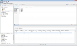
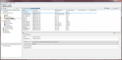
The parameters of the overlays is listed in the tables of DRWBM profiles DRWBM Profile (see Figure : DRWBM Profile ) and der Overlay Definition (see Figure: Overlay Definitions ).
DRWBM Profile
The multi-layer structure of the intensive by the DRWBM is defined in the profiles table DRWBM. This involves the following parameters:
| Soil Horizon | Thickness [dm] | Interflow | Pipe roughness [mm] | Rohr Rauheit ks [mm] | Longest flow path per outlet [m] | Slope of the drainage pipe [%] | Overflow Height [mm] | Overflow Layer | Measure outlet per area [m²] | Underlying sealing layer ? | Description |
|---|---|---|---|---|---|---|---|---|---|---|---|
| Soil Horizon(Link) | Number (double) | Checkfield: Yes/No | Number (double) | Number(double) | Number(double) | Number(double) | Number(double) | Number(integer) | Number(double) | Check field: Yes/No | [Text] |
- Name
- Name of the DRWBM profile (maximum length of 8 characters)
- Description
- Description of the DRWBM profile (optional)
- Soil horizon
- A soil type can be assigned to each horizon through a link to the soils(see: Parameter: Soil)
- Thickness
- Thickness of the soil horizon[dm].
- Interflow
- Selection, whether interflow is allowed in this horizon. (Optional)
- Pipe diameter
- Optional input from a pipe diameter [mm]. Through the input of an outlet pipe diameter, the discharge from the layer can be simulated.
- Pipe roughness [ks]
- Pipe Roughness in [mm]. The outflow pipe is throttled by a higher roughness and accelerated by a low surface roughness. (This is necessary if an outlet of the layer is defined.)
- Longest flow path per outlet
- Indication of the longest flow path in the layer [m]. (The indication is necessary if an outlet of the layer is defined.)
- Slope drain pipe [%]
- Slope of the drain pipe or the drainage layer. This is influenced by the layer of the flow speed. (This is necessary if an outlet of the layer has been defined.)
- Over flow height
- Indication of a water level in the layer before it comes to the outlet of the layer, in [mm]. (Optional)

- Overflow Layer
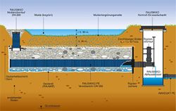
- Within the measures a layer can drain in an underlying layer. The input of a layer of overflow the Modeller allows making a coupling of layers within a DRWBM profile. As shown in overflow of a hollow layer in the including trench is shown to an overflow in the trench (Layer 3) achieve the maximum abundance of a hollow (Layer 1). Input of the overflow layer is layer 1, with overflow layer "3".
- Measure area per outlet [m²]
- Per outlet, a certain area of the measure can be drained. (This is necessary if an outlet of the layer has been defined)
- Seal underneath the layer?
- Sealing of the layer downwards. The water cannot percolate downwards. (Optional)
Overlay Definition
In the overlay, definitions can be linked to the data units of the overlays. This includes the data of the DRWBM soil profiles and the land use Group of pedology. Providing the data is optional. At the intersection of the overlays with the existing hydrotope , only the data is overwritten, that have been specified here. Otherwise, the existing data of the model are preserved. This involves the following options:
| Name | Description | DRWBM Soil profile | Land use group | Max. Percolation rate | Section of Ground water |
|---|---|---|---|---|---|
| [Text] | [Text] | DRWBM-Soil profile (Link) | Land Use (Link) | Number(double) | Number (double) |
- Name
- The name of the overlay definition.
- Description
- The description of the overlay. (Optional)
- DRWBM Soil profile
- Link to the DRWBM soil profiles. (Optional)
- Land Use Group
- Link to the land use classes. (Optional)
- Maximum rate of percolation
- Hydraulic conductivity, with which the water can percolate/ penetrate to the last layer of groundwater.
- Section of Ground Water
- Section of the ground water that remains in the upper aquifer. The proportion of the difference will be cut off in the deep aquifer.
| Language: | English • Deutsch |
|---|

