Data Import for Hydrotope Intersection and Overlay Integration
Importieren von Shape Dateien
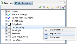
The import of data to create Hydrotops is done via the “Map View” in the Outline View of the Hydrotope. The Import function is opened from the right-click menu (see Figure: Importing Shape Files.
Shape file Import
The import of the Shape files can be done via the input window: Shape file Import. In the figure Shape file Import is exemplified for the import of the land use file. The existing attributes of the shape file are displayed via drop -down menus, and can then be assigned.
The following entries and assignments of records shall be made during shapefiles Import:
Land Use
| Import Land Use
|
| Shape file |
Input link
|
| Coordinate Systems |
z.B. DHDN / 3degree Gauss Kruger zone 3
|
| Land Use |
Land use Name [Text]
|
| Correction factor of Sealing rate |
[Number (double)]
|
Pedology
| Import Pedology
|
| Shape file |
Input link
|
| Coordinate system |
z.B. DHDN / 3degree Gauss Kruger zone 3
|
| Soil Key |
Soil profile Name [Text]
|
Geology
| Import Pedology
|
| Shape file |
Input link
|
| Coordinate system |
z.B. DHDN / 3degree Gauss Kruger zone 3
|
| Max. Percolation rate |
[Number(double)]
|
| Portion of inflow to the GW |
[Number(double)]
|
Overlay (DRWBM)
| Import Overlay
|
| Coordinate system |
z.B. DHDN / 3degree Gauss Kruger zone 3
|
| Description |
[Text]
|
| Overlay Definition |
Name of the Overlay Definition [Text]
|
After importing the data, the hydrotope can be recreated. See Figure: Generate Hydrotope
For further processing of the data see: Views for editing the Hydrotope.


