Difference between revisions of "ModelParameter/hydrology/en"
BhawaniRegmi (Talk | contribs) (Created page with "== Model parameter == Ansicht der Übersicht der Modellparameter === Ansichten zur Bearbeitung der Modellparameter=== Dies...") |
BhawaniRegmi (Talk | contribs) |
||
| Line 1: | Line 1: | ||
== Model parameter == | == Model parameter == | ||
| − | [[File:Modellparameter Uebersicht.jpg|400px|thumb| | + | [[File:Modellparameter Uebersicht.jpg|400px|thumb|Views for editing the model parameter]] |
| − | === | + | === Views for editing the model parameter === |
| − | + | This item consists of the following five windows: | |
| − | ; | + | ; Overview |
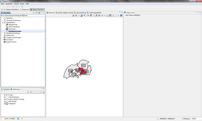
| − | : | + | : Shows the model elements in the map overview (see Figure [[:File:Modellparameter Uebersicht.jpg|''Views for editing the model parameter'']]) |
| − | ; Kalinin-Miljukov | + | ; Kalinin-Miljukov strand |
| − | : | + | : Selection of KM strands to define model parameters. |
| − | ; | + | ; Reservoir Strand |
| − | : | + | : Selection of reservoir strands to define the model parameters. |
| − | ; | + | ; Sub catchments |
| − | : | + | : Selection of Sub-catchments to define the model parameters |
{{Clear}} | {{Clear}} | ||
=== Kalinin-Miljukov Strang === | === Kalinin-Miljukov Strang === | ||
| − | [[File:Modellparameter Kalinin-Miljukov Straenge.jpg|400px|thumb| | + | [[File:Modellparameter Kalinin-Miljukov Straenge.jpg|400px|thumb|View of the overview of the Kalinin-Miljukov model parameters]] |
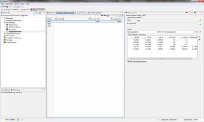
| − | In | + | In the ''Kalinin-Miljukov Strand''- View (see Figure [[:File:Modellparameter Kalinin-Miljukov Straenge.jpg|''Overview of the Kalinin-Miljukov model parameters'']]). It is also possible to specify the length of the water way (''Downstream [km]'' and ''Upstream [km]''). <br /> |
| − | + | In Feature View the details of the ''Kalinin - Miljukov'' parameters are stored. Currently 5 runoff cases for the model structure are needed. The details of the outflow cases are listed in the following table: | |
{| class="wikitable" | {| class="wikitable" | ||
|- | |- | ||
| − | |colspan="4" style="text-align:center" | ''' | + | |colspan="4" style="text-align:center" | '''Channel''' |
|- style="text-align:center" | |- style="text-align:center" | ||
| − | |'''Parameter'''||''' | + | |'''Parameter'''||'''Unit'''||'''Description'''||'''Data type''' |
|- | |- | ||
| − | | | + | | Inflow/ discharge||[m³/s]||Discharge. 5 different discharge cases should be specified ||double |
|- | |- | ||
| − | |K | + | |K Flow||[h]||Retention constant K of the main river (Kalinin-Miljukov)||double |
|- | |- | ||
| − | |n | + | |n Flow||[-]||Approach in the river strand (Kalinin- Miljukov)||double |
|- | |- | ||
| − | |K | + | |K Bank ||[h]||Retention constant K of the river bank (Kalinin-Miljukov)||double |
|- | |- | ||
| − | |n | + | |n Bank ||[-]||Approach in the river strand model for the river banks (Kalinin- Miljukov||double |
|- | |- | ||
| − | | | + | |Distribution factor||[-]||Distribution factor of the channel-bank/ foreland or run off percentage respectively, which is discharged through the main river.||double |
|} | |} | ||
{{Clear}} | {{Clear}} | ||
| − | {{Info_tip| | + | {{Info_tip|The Kalinin-Miljukov (KM) parameters are determined by a 1D- model calculation with Kalypso WSPM. To do this, a board full calculation is performed (stationary non-uniform), which provides the water level for the KM parameter calculation. Required data are the area, and width values for a number of river profiles per strand.}} |
| − | + | A wizard ''Calculate KM parameter'' opens to calculate the Kalinin Miljukov parameter. | |
| − | [[File:KM Parameter berechnen.png|400px|thumb|Kalinin-Miljukov | + | [[File:KM Parameter berechnen.png|400px|thumb|Kalinin-Miljukov Parameter Dialogue]] |
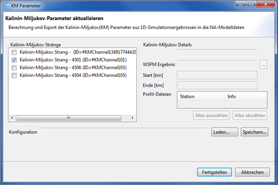
| − | + | The Kalinin Miljukov parameter dialog is divided into two areas(see Figure [[:File:KM Parameter berechnen.png|''Kalinin-Miljukov-Parameter Dialogue'']]). On the left side all Kalinin - Miljukov strands of the model are displayed. For the selected string in the right panel a ''WSPM Result'' is selected, which contains input data for a KM - calculation. Over the button next to the text box of WSPM result, an existing WSPM result is selected. The present result profile stations are listed in the table and must be selected for specific KM strands. The KM – strands are entered from / to, ''Start [km]'' and ''End [km]'', this will automatically start in the selected fields. For each strand, which is activated through the selection list, the KM - parameters are calculated and included in the model by clicking on ''Finish''. | |
| − | + | ||
| − | + | ||
| − | + | [[File:KM Parameter Ende.png|400px|thumb| Result of a calculation and transfer dialogue]] | |
| − | [[File:KM Parameter Ende.png|400px|thumb| | + | The selected settings are applied when you click Finish. The KM - parameters are calculated and written to the selected strands. Already present parameters are overwritten. After the calculation and transfer of results a progress dialogue is displayed in which any warnings and problems are listed (see Figure [[:File:KM Parameter Ende.png|''Result of a calculation and transfer dialogue'']]). Double-clicking a message opens a more detailed message. |
| − | + | ||
<br /> | <br /> | ||
| − | + | If settings for later acquisition are stored, for example, to refresh after a recalculation WSPM the KM parameters, a file is selected on the ''Save'' button. In these settings the information is stored in XML format. The ''Store'' button can be used again later in this file. The previous settings are then restored and the parameters can be recalculated. | |
<br /> | <br /> | ||
| − | {{Info_tip| | + | {{Info_tip|For the calculation of the KM parameters, those stations must be selected per KM strand which are typical for the section represented by this section. The selection of all stations does not always make sense. In particular, it is has to be ensured that a monotonous representation of flow curves is provided by the WSPM results.}} |
| − | {{Info_tip| | + | {{Info_tip|The number of sections n shall be limited to a maximum of 30.}} |
{{Clear}} | {{Clear}} | ||
| − | === | + | === Reservoir Strand === |
| − | [[File:Modellparameter Speicherstrang.jpg|400px|thumb| | + | [[File:Modellparameter Speicherstrang.jpg|400px|thumb|View of the model parameters in Reservoir strands]] |
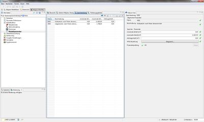
| − | In | + | In the ''Reservoir strand'' view (see Figure [[:File:Modellparameter Speicherstrang.jpg|''View of the model parameters in Reservoir strands'']]) are maintained for reservoir strands: |
{| class="wikitable" | {| class="wikitable" | ||
|- | |- | ||
| − | |colspan="4" style="text-align:center" | ''' | + | |colspan="4" style="text-align:center" | '''Reservoir strand -Parameter''' |
|- style="text-align:center" | |- style="text-align:center" | ||
| − | |''' | + | |'''Minimum Content [m³]'''||'''Maximum content[m³]'''||'''Initial content [m³]'''||'''WVQ-relationship''' |
|- | |- | ||
| − | |double||double||double||WVQ-Diagramm [Link zum [[Parameterdefinition/Zeitreiheneditor/hydrology/de | | + | |double||double||double||WVQ-Diagramm [Link zum [[Parameterdefinition/Zeitreiheneditor/hydrology/de |Time Series Editor]]] |
|} | |} | ||
| − | *'' | + | *''Minimal content [m³]'': Minimum storage Content |
| − | *'' | + | *''Maximum content [m³]'': Maximum storage content |
| − | *'' | + | *''Initial start content [m³]'': Basin content at the beginning of the simulation |
| − | *''WVQ- | + | *''WVQ-relationship'': Relationship between water level [mNN] = W, volume/contents [m ³] = V and discharge [ m³/s] = Q from the reservoir strand (max. 23 value triples can be defined)see [[Parameterdefinition/Zeitreiheneditor/hydrology/de|Time Series Editor]] |
| − | + | ||
| − | {{Info_tip| | + | {{Info_tip|In the case of the classic flood relief systems (only basic discharge), the import of the water level volume-outflow relationship for the 1st discharge and the second discharge in the table / diagram is set to zero automatically.}} |
{{Clear}} | {{Clear}} | ||
| − | === | + | === Sub Catchments === |
| − | [[File:Modellparameter Teileinzugsgebiete.jpg|400px|thumb| | + | [[File:Modellparameter Teileinzugsgebiete.jpg|400px|thumb|View of the Sub-catchment of the model parameters]] |
| − | + | The View of the ''Sub-catchment'' (see Figure [[:File:Modellparameter Teileinzugsgebiete.jpg|''view of the Sub catchment of the model parameters'']]) gives the following information: | |
{{Clear}} | {{Clear}} | ||
{| class="wikitable" | {| class="wikitable" | ||
|- | |- | ||
| − | |colspan="4" style="text-align:center" | ''' | + | |colspan="4" style="text-align:center" | '''Design Rainfall Event''' |
|- style="text-align:center" | |- style="text-align:center" | ||
| − | |'''Parameter'''||''' | + | |'''Parameter'''||'''Unit'''||'''Description'''||'''Data type''' |
|- | |- | ||
| − | | | + | |Synthetic Rainfall ||[-]||Selection of the region of the design rainfall (Classification see ''Synthetic Rainfall'')||Text |
|} | |} | ||
{| class="wikitable" | {| class="wikitable" | ||
|- | |- | ||
| − | |colspan="4" style="text-align:center" | ''' | + | |colspan="4" style="text-align:center" | '''Snow''' |
|- style="text-align:center" | |- style="text-align:center" | ||
| − | |'''Parameter'''||''' | + | |'''Parameter'''||'''Unit'''||'''Description'''||'''Data type''' |
|- | |- | ||
| − | | | + | |Snow type||[-]||Assign the snow parameters||Text |
|} | |} | ||
| Line 109: | Line 105: | ||
|colspan="4" style="text-align:center" | '''Retention - Translation''' | |colspan="4" style="text-align:center" | '''Retention - Translation''' | ||
|- style="text-align:center" | |- style="text-align:center" | ||
| − | |'''Parameter'''||''' | + | |'''Parameter'''||'''Unit'''||'''Description'''||'''Data type''' |
|- | |- | ||
| − | |k QObfl.vers.||[h]|| | + | |k QObfl.vers.||[h]||Retention constant of sealed surfaces runoff||Number (double) |
|- | |- | ||
| − | |k QObfl.nat.||[h]|| | + | |k QObfl.nat.||[h]||Retention constant of natural surface runoff ||Number(double) |
|- | |- | ||
| − | |k QIntf.||[h]|| | + | |k QIntf.||[h]||Retention constant of the unsaturated soil water flow (Interflow)||Number(double) |
|- | |- | ||
| − | |k QBasis||[h]|| | + | |k QBasis||[h]||Retention constant of the base flow||Number (double) |
|- | |- | ||
| − | |k QGw||[h]|| | + | |k QGw||[h]||Retention constant of groundwater runoff in neighbouring areas||Number (double) |
|- | |- | ||
| − | |k Q | + | |k Q deep Gw||[h]||Retention constant of the groundwater flow||Number (double) |
|- | |- | ||
| − | | | + | |Time Area Function||[h,-]||Time area function; active drained area (normalized) as a function of time (must be specified for each user from the sub-catchments) **||Diagram |
|} | |} | ||
| − | {{Info_tip|** | + | {{Info_tip|**To enter of the time area function, the time series editor opens. For details on the handling of the time series editor,See [[Parameterdefinition/Zeitreiheneditor/hydrology/de|Time Series Editor]].}} |
{| class="wikitable" | {| class="wikitable" | ||
|- | |- | ||
| − | |colspan="4" style="text-align:center" | ''' | + | |colspan="4" style="text-align:center" | '''Groundwater''' |
|- style="text-align:center" | |- style="text-align:center" | ||
| − | |'''Parameter'''||''' | + | |'''Parameter'''||'''Unit'''||'''Description'''||'''Data type''' |
|- | |- | ||
| − | |min h | + | |min h of Groundwater||[m]||Minimum storage level of aquifers. Groundwater storage level at which the first water contact exists||Number (double) |
|- | |- | ||
| − | |max h | + | |max h of Groundwater||[m]||Minimum groundwater storage level. Groundwater storage level point on reaching the highest riverbed||Number (double) |
|- | |- | ||
| − | | | + | |Distribution factor GW||[ - ]||Distribution factor of near-surface and deep aquifers (see note below) || Number(double) |
|- | |- | ||
| − | | | + | |Porosity of Groundwater||[ - ]||Porosity of Groundwater aquifers||Number (double) |
|- | |- | ||
| − | | | + | |Sampling ground water||[m³/s]||Continuous withdrawal from the aquifer (e.g. for water works) ||Number(double) |
|} | |} | ||
| − | {{Info_tip| | + | {{Info_tip|The distribution factor of the shallow and deep aquifer is given as a percentage in [%]. The proportion is specified here, which remains in the near-surface aquifers. This portion is the near-surface groundwater share of the geological data per hydrotope(see[[Hydrotope/hydrology/de#Geologie_.28Erstellung_Hydrotope.29|Geology (Generate Hydrotopes)]]. If the corrected value is greater than 100% in the derived deep aquifers or shallow aquifers, a correction of the values is done.}} |
| − | {{Info_tip| | + | {{Info_tip|The continuous withdrawal of groundwater is given as a positive value. If a negative value is entered, a continuous inflow is calculated into the groundwater storage.}} |
| − | {{Info_tip| | + | {{Info_tip|When the ground water level exceeds the maximal storage level the percolated water is applied to the base flow. To achieve the maximum ground water level, the modeler needs to give the information after simulation and the maximum ground water height has to be adjusted where appropriate. }} |
<br /> | <br /> | ||
[[Category:Hydrology/en]] | [[Category:Hydrology/en]] | ||
{{Languages|Net elements/hydrology}} | {{Languages|Net elements/hydrology}} | ||
Revision as of 22:51, 15 February 2017
Contents |
Model parameter
Views for editing the model parameter
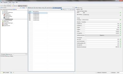
This item consists of the following five windows:
- Overview
- Shows the model elements in the map overview (see Figure Views for editing the model parameter)
- Kalinin-Miljukov strand
- Selection of KM strands to define model parameters.
- Reservoir Strand
- Selection of reservoir strands to define the model parameters.
- Sub catchments
- Selection of Sub-catchments to define the model parameters
Kalinin-Miljukov Strang
In the Kalinin-Miljukov Strand- View (see Figure Overview of the Kalinin-Miljukov model parameters). It is also possible to specify the length of the water way (Downstream [km] and Upstream [km]).
In Feature View the details of the Kalinin - Miljukov parameters are stored. Currently 5 runoff cases for the model structure are needed. The details of the outflow cases are listed in the following table:
| Channel | |||
| Parameter | Unit | Description | Data type |
| Inflow/ discharge | [m³/s] | Discharge. 5 different discharge cases should be specified | double |
| K Flow | [h] | Retention constant K of the main river (Kalinin-Miljukov) | double |
| n Flow | [-] | Approach in the river strand (Kalinin- Miljukov) | double |
| K Bank | [h] | Retention constant K of the river bank (Kalinin-Miljukov) | double |
| n Bank | [-] | Approach in the river strand model for the river banks (Kalinin- Miljukov | double |
| Distribution factor | [-] | Distribution factor of the channel-bank/ foreland or run off percentage respectively, which is discharged through the main river. | double |
| The Kalinin-Miljukov (KM) parameters are determined by a 1D- model calculation with Kalypso WSPM. To do this, a board full calculation is performed (stationary non-uniform), which provides the water level for the KM parameter calculation. Required data are the area, and width values for a number of river profiles per strand. |
A wizard Calculate KM parameter opens to calculate the Kalinin Miljukov parameter.
The Kalinin Miljukov parameter dialog is divided into two areas(see Figure Kalinin-Miljukov-Parameter Dialogue). On the left side all Kalinin - Miljukov strands of the model are displayed. For the selected string in the right panel a WSPM Result is selected, which contains input data for a KM - calculation. Over the button next to the text box of WSPM result, an existing WSPM result is selected. The present result profile stations are listed in the table and must be selected for specific KM strands. The KM – strands are entered from / to, Start [km] and End [km], this will automatically start in the selected fields. For each strand, which is activated through the selection list, the KM - parameters are calculated and included in the model by clicking on Finish.
The selected settings are applied when you click Finish. The KM - parameters are calculated and written to the selected strands. Already present parameters are overwritten. After the calculation and transfer of results a progress dialogue is displayed in which any warnings and problems are listed (see Figure Result of a calculation and transfer dialogue). Double-clicking a message opens a more detailed message.
If settings for later acquisition are stored, for example, to refresh after a recalculation WSPM the KM parameters, a file is selected on the Save button. In these settings the information is stored in XML format. The Store button can be used again later in this file. The previous settings are then restored and the parameters can be recalculated.
| For the calculation of the KM parameters, those stations must be selected per KM strand which are typical for the section represented by this section. The selection of all stations does not always make sense. In particular, it is has to be ensured that a monotonous representation of flow curves is provided by the WSPM results. |
| The number of sections n shall be limited to a maximum of 30. |
Reservoir Strand
In the Reservoir strand view (see Figure View of the model parameters in Reservoir strands) are maintained for reservoir strands:
| Reservoir strand -Parameter | |||
| Minimum Content [m³] | Maximum content[m³] | Initial content [m³] | WVQ-relationship |
| double | double | double | WVQ-Diagramm [Link zum Time Series Editor] |
- Minimal content [m³]: Minimum storage Content
- Maximum content [m³]: Maximum storage content
- Initial start content [m³]: Basin content at the beginning of the simulation
- WVQ-relationship: Relationship between water level [mNN] = W, volume/contents [m ³] = V and discharge [ m³/s] = Q from the reservoir strand (max. 23 value triples can be defined)see Time Series Editor
| In the case of the classic flood relief systems (only basic discharge), the import of the water level volume-outflow relationship for the 1st discharge and the second discharge in the table / diagram is set to zero automatically. |
Sub Catchments
The View of the Sub-catchment (see Figure view of the Sub catchment of the model parameters) gives the following information:
| Design Rainfall Event | |||
| Parameter | Unit | Description | Data type |
| Synthetic Rainfall | [-] | Selection of the region of the design rainfall (Classification see Synthetic Rainfall) | Text |
| Snow | |||
| Parameter | Unit | Description | Data type |
| Snow type | [-] | Assign the snow parameters | Text |
| Retention - Translation | |||
| Parameter | Unit | Description | Data type |
| k QObfl.vers. | [h] | Retention constant of sealed surfaces runoff | Number (double) |
| k QObfl.nat. | [h] | Retention constant of natural surface runoff | Number(double) |
| k QIntf. | [h] | Retention constant of the unsaturated soil water flow (Interflow) | Number(double) |
| k QBasis | [h] | Retention constant of the base flow | Number (double) |
| k QGw | [h] | Retention constant of groundwater runoff in neighbouring areas | Number (double) |
| k Q deep Gw | [h] | Retention constant of the groundwater flow | Number (double) |
| Time Area Function | [h,-] | Time area function; active drained area (normalized) as a function of time (must be specified for each user from the sub-catchments) ** | Diagram |
| **To enter of the time area function, the time series editor opens. For details on the handling of the time series editor,See Time Series Editor. |
| Groundwater | |||
| Parameter | Unit | Description | Data type |
| min h of Groundwater | [m] | Minimum storage level of aquifers. Groundwater storage level at which the first water contact exists | Number (double) |
| max h of Groundwater | [m] | Minimum groundwater storage level. Groundwater storage level point on reaching the highest riverbed | Number (double) |
| Distribution factor GW | [ - ] | Distribution factor of near-surface and deep aquifers (see note below) | Number(double) |
| Porosity of Groundwater | [ - ] | Porosity of Groundwater aquifers | Number (double) |
| Sampling ground water | [m³/s] | Continuous withdrawal from the aquifer (e.g. for water works) | Number(double) |
| The distribution factor of the shallow and deep aquifer is given as a percentage in [%]. The proportion is specified here, which remains in the near-surface aquifers. This portion is the near-surface groundwater share of the geological data per hydrotope(seeGeology (Generate Hydrotopes). If the corrected value is greater than 100% in the derived deep aquifers or shallow aquifers, a correction of the values is done. |
| The continuous withdrawal of groundwater is given as a positive value. If a negative value is entered, a continuous inflow is calculated into the groundwater storage. |
| When the ground water level exceeds the maximal storage level the percolated water is applied to the base flow. To achieve the maximum ground water level, the modeler needs to give the information after simulation and the maximum ground water height has to be adjusted where appropriate. |
| Language: | English |
|---|
